
Upcoming Events and Workshops
Successful completion of a workshop will result in participants being awarded an Attendance Certificate stating CPD hours.
|
Cancellation fees (prior to start date) |
More than 10 working days |
No fee |
|
Less than 10 working days |
50% of course cost |
|
|
Transfer (prior to start date) |
More than 10 working days |
Please email: Rachael Armstrong |
|
Less than 2 working days |
Will be treated as a cancellation |
|
|
Substitute delegates |
Is available |
Please email: Rachael Armstrong |
Catch up for coffee with your regional river group members
Join the Rivers Group for a relaxed and engaging coffee catch-up with fellow river enthusiasts, professionals, and anyone passionate about our waterways. Whether you work in the sector, have a keen interest in river projects, or simply enjoy connecting with like-minded people, these informal meetups are a great opportunity to expand your network and share ideas.
Come along for great coffee, meaningful conversations, and the chance to connect with others who care about rivers and the communities around them.
Date: Friday 28 Augsut 2026
Time: 10:30am
Location: Wellington
Faithful flavours cafe 4 Chews Lane, Wellington Central, Wellington
Location: Christchurch
THE WELDER, 22 Welles Street
Gravel Management Workshop
In August 2025, we delivered a gravel workshop in Wellington. While previously run over two days, this workshop is now delivered as a one‑day format.
A 1-day workshop on all things gravel extraction including background on the theory of bedload transport, bed level changes and the effects of gravel extraction, discussion of the various potential consequences of over extraction, and approaches to assessing sustainable extraction volumes. The workshop includes a mixture of expert presentations and facilitated discussions to share experiences from around the country.
Date: 11 August 2026
Time: 8:30am – 5:00pm
Venue: Epic Innovations, Christchurch
Agenda
Gravel Movement in Rivers
Jon Tunnicliffe, University of Auckland
Gravel Extraction and River Equilibrium
Jon Tunnicliffe, University of Auckland
Group Discussion: Share participant experiences of problems relating to gravel extraction
Facilitator: Dr. Alastair Clement, Tasman District Council
Wider Considerations Around Gravel Extraction Effects of over-extraction on: Groundwater; Habitat, Coastal erosion
Richard Measures, Earth Science
A Council Perspective on Changing Approaches to Assessing Gravel Volumes
Dr. Alastair Clement, Tasman District Council
Group Discussion: Share participant approaches to assessing and consenting sustainable extraction volumes
Facilitator: Dr. Alastair Clement
Attendee Cost: $550.00pp (Council discount $100)
Workshop: Moving towards Strategic Gravel Management
Exploring national consistency in responding to common challenges
Date: 12 August 2026
Time: 8:30am – 4:30pm
Cost: $150pp plus GST
Venue: Epic Innovations, Christchurch
Target audience: Stakeholders with an interest in gravel management and extraction activities in New Zealand rivers.
Key Themes:
- Communities: values, expectations, perceptions, preconceptions, challenges
- Gravel volumes/resources: measuring, monitoring, approaches, techniques, challenges
- Impacts of extraction: ecology, groundwater, geomorphology, and monitoring
- Alternatives: gravel management not through extraction, approaches, techniques, challenges
- Current and future practices: operational considerations, challenges, state of the space in which gravel extraction occurs e.g., NPS-FM, future Environment and Planning Bills.
The workshop will be a mixture of short presentations and group discussions. The intent is to identify where a shared gravel management approach nationwide is appropriate (and where local differences should be maintained).
Participants are encouraged to watch the Environment Canterbury webinar outlining their recently updated Gravel Management Strategy and Code of Practice. This session will build on and complement the topics covered in the 11 August webinar. All participants are expected to view the webinar. A recording link will be provided for those who are unable to attend the live session Development Programme | Resilient River Communities
To register for this workshop email Rachael.Armstrong@hbrc.govt.nz
Attendees will a CPD certificate for completing the course.
Smarter Asset Management for River Teams
Level One Asset Management Course
This introductory course provides a contextual overview of the core elements of Asset Management (AM).
About the Course
Want to make better, more defensible decisions about your assets—without getting lost in theory?
This practical, introductory course provides a clear, real-world overview of Asset Management (AM), tailored for those working with infrastructure and river assets.
Using case studies from across industries, we’ll explore:
- Why asset management matters
- How to manage assets across their lifecycle
- How to identify and manage risks
- What good asset management looks like in practice
By the end of the course, you’ll: ✔ Understand the core elements of asset management
✔ Be able to apply AM concepts in your day-to-day role
✔ Have the tools to build or improve an Asset Management Plan aligned to organisational outcomes
Who Should Attend
- River Managers
- Asset/Infrastructure planners
- Engineers and technical staff
- Anyone involved in AM plans or LTP preparation
What We’ll Cover
- Introduction and course overview
- Asset management fundamentals
- Organisational context and governance
- Understanding the state of your assets
- Valuation and lifecycle implications
- Levels of service – are you delivering what’s needed?
- Risk management
- Lifecycle management strategies
- Building an Asset Management Plan
- Continuous improvement
- Managing the AM journey
Presenter: Catherine Bayly
Catherine is an experienced Infrastructure and Asset Manager. She has worked with and for local government organisations for over 20 years in NZ, Australia and the UK. Example work includes physical delivery of capital projects up to $300m, management of city assets, auditing AM competency of international water and river management schemes and most recently the design and completion of a national asset management system for the NZ Water Industry. Cath has co-developed competency based asset management courses in Australia which have been delivered to large scale asset owners including BHP Billiton, the defence force and the water industry. Cath has competencies in all elements of asset management and is particularly passionate about continuous improvement to efficiently deliver community services
When
Monday 17 August 2026
Where
Auckland, CBD
Time
9:00am - 5:00pm
Cost
$500.00 plus GST.
Council rate – $400.00 plus GST
Where to register
Email Rachael Armstrong - Rachael.Armstrong@hbrc.govt.nz
Attendees will a CPD certificate for completing the course.
Designing Culverts Using the NZ Fish Passage Guidelines – Practical Workshop
Date: 30 September 2026
Location: Auckland
Time: 9.00am - 5:00pm (catering included)
Cost: $600.00 plus GST.
Register by emailing: Rachael.Armstrong@hbrc.govt.nz
Spaces are limited!
Designing Culverts Using the NZ Fish Passage Guidelines – Practical Workshop
A hands-on session predominately for engineers, but also useful for others such as ecologists and planners, working in freshwater infrastructure. Learn to design fish-passable culverts using the latest 2025 NZ Fish Passage Guidelines. This workshop includes step-by-step examples using HY-8 and HEC-RAS, with expert guidance from the guideline authors. It will cover culvert embedment, velocity profiles, stream simulation, and design for challenging environments. Participants are encouraged to bring laptops for active involvement.
Workshop Agenda
1. Introduction & Overview
- Overview of the fish passage and design methodology.
- Importance of fish passage: ecological, legislative, and design considerations.
2. Understanding Fish Passage
- What is fish passage and why does it matter?
- New Zealand freshwater fish: life history and migratory needs.
- Migration:
- Life stages and seasonal migration calendar.
- Flow triggers for migration.
- Target species focus: swimmers, climbers; relevant life stages.
- Fish swimming performance:
- Velocity types: sustained, prolonged, burst.
- Duration and capability: swimming, jumping, climbing.
- Behavioural considerations: flow preferences, location in the water column, use of edges/slopes.
- Culvert impacts on fish passage:
- Case examples (e.g., velocity barriers, physical barriers, exclusion of certain life stages/species).
- When barriers are beneficial (e.g., for excluding undesirable species).
3. Hydrology for Fish Passage Design
- Identifying appropriate design flows for fish passage.
- Understanding velocity distribution:
- Application to natural streams and culverts.
- Use in fish passage planning and design.
4. Culvert Embedment Design
- Embedment techniques and materials:
- Riprap sizing (soil-filled and void-filled).
- Boulder sizing and Manning’s roughness coefficients.
- Using depth-averaged velocity profiles in vertical slices.
5. Fish-Passable Culvert Design Using HY-8
- Step-by-step design of a fish-passable culvert.
- Considerations for meeting fish passage criteria.
- Limitations
6. Fish-Passable Culvert Design Using HEC-RAS
- Step-by-step design of a fish-passable culvert
- Limitations
7. Enhancing Culverts for Fish Passage
- Incorporating stilling basins.
- Overview of physical additions:
- Ramps
- Baffles
- Maintenance considerations for passage features.
Lunch Break
7. Stream Simulation in Culvert Design
- Principles of stream simulation:
- Mimicking natural stream conditions within culverts.
- Special considerations for scour protection, sizing, and shaping.
- Embedment and roughness treatments.
8. Stream Simulation Using HEC-RAS
- Walkthrough: designing a culvert using HEC-RAS with stream simulation principles.
- Limitations and challenges
9. Designing for Challenging Environments
- Fish passage design adaptations for:
- Coastal and estuarine areas
- Steep terrain
- High elevations
- Headwaters and upper catchments
10. Workshop Wrap-Up
- Summary of methodology and design tools.
- Review of key considerations in fish passage culvert design.
- Q&A and participant discussion.
Software Requirements
Participants are encouraged to bring a laptop with HY-8 installed to actively engage in the design exercises.
Download HY-8 here: HY-8 Version 8.00.2
Presenter Eugene Vodjansky
Rock Design for River Works
Date Friday 30 October 2026
Location GWRC, 100 Cuba Street, Wellington CBD
Time 9:30-4:00pm
Cost $550 plus GST. Council staff $100 discount
A workshop for designing rock revetments and groynes for River Works
A half-day workshop providing details of best practice methods for designing rock for use in river works. A high-level introduction to geomorphology will be provided for the purpose of understanding how rock works can affect river processes as well as key concepts affecting general scour design. A summary of tools for quantifying hydrological and hydraulic design parameters will be presented followed by guidance on when rock should be considered as a management tool. The design process will then be explained for rock revetments (rock lines) and groynes including general arrangement geometry, sizing, filters, and specifications. Examples will be provided of recent projects including where design/cost/maintenance trade-offs were considered.
Key themes
- Brief introduction to geomorphology – how rivers work.
- Outline tools for quantifying key design inputs – hydrology, hydraulics.
- When to use rock.
- General arrangement geometry for groynes & revetments.
- Estimating general scour (geomorphic change);
- Estimating local scour.
- Sizing rock using three different methods.
- Design of granular and geotextile filters.
- Key specifications for rock.
Outcomes
A better understanding of designing rock for use in river works.
Who would benefit?
Local authority engineers and asset managers, consultants and contractors actively involved in river management, or who have a specific interest in and experience of rivers and their management.
Presenter
Kyle Christensen, Christensen Consulting
Spaces limited
To register email Rachael.Armstrong@hbrc.govt.nz
Attendees will a CPD certificate for completing the course.
Key Learning Objectives/Outcomes
Familiarity with key principles in fluvial geomorphology and their application to various river management situations (e.g., catchment (and regional) planning, sediment flux issues, and relation to flood hazards). Build familiarity with key principles in fluvial geomorphology and their application to various river management situations
When: TBC
Where: Wellington and Waikanae
Time: Two full days (8am-5pm), exact times to be confirmed
Cost
$1300.00 plus GST for 2-day course. Council rate – $800.00 plus GST
Where to register
Email Rachael Armstrong - Rachael.Armstrong@hbrc.govt.nz
Key themes
Management issues for which geomorphic insight is fundamental:
- Work with the river (nature-based solutions) – respect diversity, work with process
- Determine what is realistically achievable
- Be proactive, precautionary, pre-emptive – tackle threatening processes
- Risk management
- Integrated Catchment Management
- Active and passive practices (including the do-nothing option) – hard versus soft engineering practices … Role of maintenance (weed management)
- Flood management/protection versus ‘living with a living river’
- Managing river erosion
- Using sediment budgets to manage sedimentation issues (including sand/gravel extraction)
Spatial Dimensions of geomorphologically-informed river management
Catchment
- Fundamental geomorphic unit
- Longitudinal profile – source, transfer accumulation zones
- Network relationships (tributary-trunk stream pattern, flux)
- Connectivity relationships
Channel planform: Braided, wandering gravel-bed, active meandering passive meandering, discontinuous watercourse (wetland/swamp)
Channel geometry
- Downstream and at-a-station hydraulic geometry
- Size and shape
Geomorphic units
- Erosional and depositional forms (and process relations)
- Channel (instream) and floodplain
- Assemblages – and approach to analysis of morphodynamics, condition, recovery (Fryirs & Brierley, 2021)
Bed material size
- Bedrock, Boulder/cobble, gravel-bed, sand-bed, fine-grained
- Bedload, mixed load, suspended load
Temporal dimensions of geomorphologically-informed river management
Timescale: Geologic, geomorphic, engineering
Magnitude-frequency relations
Equilibrium versus non-linear relations
Legacy effect (landscape memory)
Processes of geomorphic river adjustment
- Balance of impelling and resisting forces
- Stream power, shear stress
- Resistance elements – role of riparian vegetation, wood, ecosystem engineers
- Entrainment, transport, deposition (Hjulstrom curve)
- Sediment transport – Bedload, suspended load, solution load
- Aggradation/degradation regime – Lane Balance
Evolutionary trajectory of rivers (and recovery potential)
- Relating character and behaviour (capacity for adjustment/range of variability) to evolutionary trajectory
- Scoping (modelling) prospective river futures to determine what is realistically achievable in management
Geomorphology and river health (condition)
What do we measure where, how and why?
What do we measure against?
Geomorphic relations to Māori conceptualisations of rivers
A living river ethos, mauri, mana, ora
How geomorphology can support river management (indicative only – set up follow up specialist courses)
Scoping river futures - Proactive and precautionary approaches to Visioning & Catchment Planning
Concern for treatment response
Geoethical considerations – concerns for social and environmental justice
- Risk management
- Integrated Catchment Management
- Active and passive practices (including the do-nothing option) – hard versus soft engineering practices … Role of maintenance (weed management)
- Flood management/protection versus ‘living with a living river’
- Managing river erosion
- Using sediment budgets to manage sedimentation issues (including sand/gravel extraction)
Presenters: Ian Fuller, Gary Brierley, Jon Tunnicliffe
Attendees will a CPD certificate for completing the course.
What is a super-model – a water engineer’s perspective
Explaining the need, set-up and use of hydrodynamic models to river managers
Date 2027 TBC
Location TBC
Module 1: Hydrodynamic modelling explained.
In this module you will learn what hydrodynamic models are, their purpose, the differences in approaches that can be adopted and some of the modelling terminology that you will find in general use.
This is intended for technical staff but will be aimed at an introductory level in the modelling realm. Attendees will be expected to have a base understanding of river/stream hydraulics, pipe flow and of the rainfall-runoff process.
The content will cover numeric solution of fundamental hydraulic equations as undertaken by computational hydraulic models.
We will explain information requirements and the underlying purposes of building, calibrating and running a hydrodynamic model.
Attendees will learn what model outputs are available and how these outputs can be used.
Several examples of different model types will be discussed, noting that different models suit different situations. Furthermore, attendees will learn some situations where models may not be needed and may not be the immediate answer to many questions. A case study will be initiated that will be followed through the series of modules.
Module 2: Making use of hydrodynamic models
This module is all about the use of a model. It starts with some content on when and why a model may be required and outlines situations within which a model can be useful.
Also included is making use of a model that has already been built. This will cover pitfalls and things to watch with models that were previously built and are to be re-purposed.
We will explain how we conduct confidence tests to be sure that a model is providing reliable results. Also included is a series of situations where a model may give unreliable results, and how to notice these.
There have been many model “benchmarking” tests undertaken to quantify model accuracy, and some of these will be discussed and explained.
Module 3: Scoping a modelling investigation
Having decided that a hydrodynamic model is needed for a given purpose, there is often difficulty in scoping the model build, calibration, validation and model use process. This module is aimed at navigating this, especially if the modelling work is going to be out-sourced. This is a fundamentally important step in any modelling project, as the initial model set-up dictates the end use of the results. Topics included are data inputs, modelling tolerances, calibration and validation and design event specification. Important in any modelling process is repeatability, so the initial scoping needs to be set out in such a way to ensure this.
In recent times, models have been used for very many uses and management of the resulting data has become a major consideration. This module covers how to scope the modelling work in such a way that data management becomes more simple.
Module 4: Hardware and software
This module may not require a full hour, but will focus on some of the limitations associated with hardware and software for running models. Coupled with this is the data storage needs for storing model result files and how efficiencies can be engineered. It is usual for model results to be transmitted between agencies, and emailing (for example) of very large files is often not practical. We will discuss some of the limitations to ways by which models can be built and run, and how model results can be stored and accessed.
The session will conclude with a summary of the previous modules, together with open discussion and questions.
On behalf of the organising committee, we invite you to this year’s New Zealand Hydrological Society | New Zealand Rivers Group Joint Conference in Whakatū | Nelson.
The theme, “Ripple Effects – understanding the impacts of today’s decisions in a changing environment,” highlights how societal choices affect our water. Through collaboration and knowledge sharing, we can better understand and manage these impacts.
This conference aims to bring our fields together to address current challenges, celebrate achievements, and explore future opportunities. Alongside technical sessions, there will be networking events and a field trip on Friday to the Waimea Dam and its downstream users, including orchards, industry and market gardens.
2026 marks the 65th Anniversary of NZHS. This is the third time NZHS has hosted the conference in Nelson (previously in 1993 and 2012), and the Rivers Group last held their conference here in 2023. There are strong synergies between NZHS and the Rivers Group, and we are pleased to offer another joint conference to strengthen our collaboration.
We look forward to welcoming you to Whakatū | Nelson
Registrations are now open for this year's conference.
Plan your trip early and save!
NZHS and Rivers Group members can register now for only $650+GST
www.nzhsrivers.co.nz
Council Conversations:
Let's connect, share an idea, talk about issues and work on solutions as a team. Followed by networking.
To join email rachael.armstrong@hbrc.govt.nz
The target audience would be river practitioners interested in the following:
- Assessing gravel volumes/sediment budgets.
- Different river survey methodologies (with a main focus on LiDAR/Sonar technology).
- People who have prior experience in using the GCD software.
- People who may be interested in learning about the GCD software and its capabilities.
Key talking points:
- How people have used GCD software and what features they have found most useful.
- What settings people have used when running analyses.
- Discussing the different types of uncertainty (simple minimum level of detection vs probabilistic thresholding) when running change detections in GCD – what are the pros and cons of each type?
Te Uru Kahika is working to establish a long-term, nationally coordinated pipeline of co‑investment in flood resilience across Aotearoa New Zealand.
This full-day Regional Sector Workshop introduces a connected approach to flood risk management that supports transparent decision-making, value for money, and alignment with central government funding priorities. The workshop focuses on Stage 1 of a broader programme, setting the foundation for consistent, investment-ready flood risk management planning across regions.
Workshop Details
- Date: TBC
- Location: GWRC, 100 Cuba Street, Wellington
- Time: 9.00-5.00pm
- Audience: Council staff, consultants, and other flood risk management sector practitioners
- Cost: $350, Council employees $100 discount.
(Stage 2 of this programme will consist of repeatable one-day training courses for councils, consultants, and interested parties.)
Improving Connected Flood Risk Management Outcomes
The workshop provides a structured, collaborative forum to explore how flood risk can be identified, assessed, and managed using a consistent, multi-tooled approach.
The internationally recognised ISO 31000 Risk Management framework is used to guide the workshop. This framework underpins floodplain management planning approaches currently used across the sector and supports robust, defensible investment decisions.
Participants will work through practical examples and discussions to understand how connected flood risk management strategies can be developed at a regional scale and linked to long-term funding pipelines.
Workshop Objectives
- Raise awareness of connected flood risk management strategies
- Explore the deployment of multi-tooled flood mitigation approaches
- Set the conditions for a future Regional Sector Approach to flood risk management planning
- Support the development of a long-term central government investment pipeline
Key Themes
- Identifying flood risk issues and information sources
- Analysing flood risk, impacts, and damages
- Evaluating mitigation options using structured frameworks
- Developing integrated, investment-ready flood risk management plans
To register email rachael.armstrong@hbrc.govt.nz
Tools in Fluvial Geomorphology Workshop
Auckland
9:00 AM – 5:00 PM
Join us for a full-day workshop exploring cutting-edge tools and concepts in fluvial geomorphology. This interactive session combines theory, practical applications, and discussion to help you better understand and model river systems.
Morning Session
- Conceptual principles: How do we classify river form?
- Digital rivers – an emerging modelling toolbox
- Mapping the dynamic physical habitat mosaic of rivers – delineation of valley width, channel geometry (including bathymetric toolkits), geomorphic units
- Morphodynamic modelling & sediment flux (simulation, prediction)
Lunch
Afternoon Session
- Network-scale considerations: Geomorphic hotspots, CASCADE
- Linking historical change detection with future-focused modelling
- Leveraging readily available data sources in Aotearoa New Zealand – e.g. LiDAR, Aerial imagery, Google Earth Engine, and more
- Wrap up & Discussion
Cost: $650.00 (Council 150 Discount)
We would ask participants to bring a laptop for the toolbox workshop as we hope to do some interactive stuff at the end.
We would ask participants to bring a laptop for the toolbox workshop as we hope to do some interactive stuff at the end.
Set up: No prior modelling or programming experience is required for the workshop, though familiarity with basic GIS and an understanding of river systems will be helpful. Exercises are designed to be accessible to non-specialist participants while providing sufficient depth for technical staff. The emphasis will be on learning the array of tools that are available, how to choose the right tool, and how to leverage the results to problem solve. In a one-day workshop, we won't be able to delve deeply into the workflows, but if you have your laptop set up, you will have the opportunity to get 'hands-on' and replicate the analyses that are being demonstrated.
Presenters: Jon Tunnicliffe
Attendees will a CPD certificate for completing the course.
Room for the River Workshop
Date: TBC
Location: TBC
Time: 10am to pm
Cost: $500.00 plus GST. Council 10% discount.
A guide for putting Room for the River concepts into practice
A half-day workshop providing explanation and examples of the concepts described in the recently released NZ River Managers SIG – Room for the River Guidelines. The technical basis for the Room for the River concept will be explained along with examples of the methodology that can be used to determine river management lines and agreed intervention protocols to facilitate effective implementation.
Key themes
- What is Room for the River.
- How can it be used to manage flood and erosion risks within the context of climate change and Te mana o te wai;
- How to determine river management design lines;
- Interventions and dealing with critical assets within the river management design lines;
- Implementation enablers including planning controls.
Outcomes
A better understanding of how to derive river management design lines and how they can be implemented to achieve Room for the River outcomes.
Who would benefit?
Local authority engineers and asset managers, consultants and contractors actively involved in river management, or who have a specific interest in and experience of rivers and their management.
Presenter
Kyle Christensen, Christensen Consulting
Spaces limited
To register email Rachael.Armstrong@hbrc.govt.nz
River Mouth Management
Date: 2026 Date TBC
Location: Wellington
Time: 9.00am-4:30pm (catering included)
Cost: $800 plus GST. Council staff $200 discount
Register by emailing: Rachael.Armstrong@hbrc.govt.nz
Spaces are limited!
Improving Outcomes from River Mouth Management
A full-day interactive workshop for local authority staff, consultants, researchers, and contractors.
This workshop will provide an interactive forum to deepen your understanding of the natural processes occurring at the interface between rivers and the coastline and the methods for managing river mouth openings.
Participants will collaborate to produce a shared learnings document for river mouth management. This will include how river mouth management fits within the overall flood risk management strategy for a river, the level of certainty that can be relied on and future challenges with increased rainfall intensity, sea level rise and more severe storm surges.
Please note: This workshop does not cover emergency management responses during an event.
Key themes
- River mouth types and issues
- Coastal influences
- Geomorphological processes
- Management options
- Decision making frameworks
- Monitoring and forecasting
Outcomes
- Improved understanding of river mouth processes
- Practical insights into management tools and execution
Workshop Agenda
- Introductions & Scene Setting
- Physical Processes
- Management Options
- Monitoring & Forecasting
- Outcomes, triggers, modelling, risk
Presenters
Kyle Christensen & Richard Measures
Attendees will a CPD certificate for completing the course.
Overview
This two-day workshop is designed for practitioners involved in river management to build skills in managing riverine vegetation and controlling weed species within Canterbury's braided river systems. It will focus on best practices for balancing flood protection, biodiversity, and resilience through strategic vegetation approaches.
When: TBC
Where: Epic Innovation, Christchurch CBD
Time: Two full days (9:00am-5:00pm), exact times to be confirmed
Workshop Format
Day One (Classroom-based)
- Presentations and discussions covering identification, management strategies, and native species integration.
Day Two (Field-based)
- Site visits based to several locations on the Waimakariri to observe practical examples of species identification, weed control methods, and native planting approaches.
Key themes
Braided river weeds in Canterbury
Willows. Tools and weeds
Resilience, adaption and transition
Outcomes
A better understanding of braided river vegetation management
Who would benefit?
Practitioners practical level and engineers, operators, consultants and contractors actively involved in river management, or who have a specific interest in and experience of rivers and their management. Also relevant to operations staff who manage delivery of multi-value community benefit or biodiversity restoration projects within a flood-protection scheme.
Presenter
Greg Stanley, Environment Canterbury
Cost
$800.00 plus GST. Council $200 discount
Spaces limited
To register email Rachael.Armstrong@hbrc.govt.nz
Course Outline
Braided river weeds in Canterbury
- Intro to braided river context. Different reaches and conditions.
- Intro to weediness- what is moving where?
- Intro to basic identifications and ID tools.
- Intro to native braid vegetation.
- Vegetation stature, groups and transitions.
- RPMP weeds and control in Braids.
- Large scale control program example
- Typical weed control strategies.
- What can successful weed control look like in river management?
Willows. Tools and weeds.
- Groups, tree and shrub willow
- Species, hybrids and cultivars
- Problem species. Examples
- Grey willow in adjacent wetlands
- Purple willow in braids and behavioural changes
- Control programs and outcomes
- What can management look like in future?
Resilience, Adaption & Transition
- NbS & room for river considerations; weed impacts.
- Change and transition programs, work to change vegetation stability, diversity and cover over time
- Balancing native vegetation with management demands
- Planting specifications for multiple values examples
Recap, overview & open discussion.
Site visits to several locations where identification and control has been undertaken.
Attendees will receive a CPD certificate for completing the course.
A one-day workshop for river managers from councils and non-council entities to improve understanding of options for economic analysis and their limitations in helping make informed decisions about flood mitigation for communities. It would be presented by Peter Clough with assistance from Mike Hensen, who both have experience of economic assessment of flood and other environmental mitigation.
Date TBC
Location Wellington
Time 9am-5pm (catering included)
Cost $800 plus GST. Council staff $200 discount
Key Themes
1. Understanding the Full Economic Costs of Flooding
2. Flood Mitigation Options and Where They Work Best
3. Finding the Economically Optimal Mix
4. Methods of Economic Assessment
5. Placing Value on Diverse and Hard-to-Quantify Effects
6. Case Study Session – From Theory to Practice
Presenters
Peter Clough & Mike Hensen
Spaces limited
To register email Rachael.Armstrong@hbrc.govt.nz
Course Outline
This workshop is intended to give river managers a better understanding of how economic analysis can be used to inform choices between options for flood mitigation and help ensure better value for money from limited funds available. It outlines the full costs of flooding to better understand what can be gained from well-chosen flood mitigation, how an optimal mix of mitigation and other precautionary measures can be chose, then considers the different types of economic assessment method that can be used to compare those alternative measures on a consistent basis. After clarifying what goes into economic analysis and what it is trying to achieve, the workshop considers the methods available for incorporating in economic assessments the hard-to-quantity-and-value effects on cultural and environmental conditions and to account for uneven distribution of benefits and costs across communities. It uses selected case studies of economic assessments of actual flood mitigation schemes to illustrate the various methods used and uses discussion sessions with the workshop attendees to identify key questions with which to probe the strengths and weaknesses of the different methods and show how they can be used to inform decisions on flood mitigation options.
Contents
What are the economic costs of flooding?
- Direct costs of inundation – damage to property and infrastructure
- Indirect costs and “flow on” consequences – disruption to all activity, raising costs, reducing productivity
- Intangible losses for human well-being – fatalities, physical injury and mental stress, degradation of natural environment and loss of cultural and natural heritage
- Precautionary mitigation measures, such as costs of flood response and recovery capacity
What are the options for mitigating these costs and where do they work best?
- Protect property and activity by reducing risk of flooding – stopbanks, adjustable weirs etc – depends on how well the protection engineering anticipates the size of future events and how the flood protection change land use.
- Accommodate flooding by reducing its severity – elevate buildings on stilts, raise power points – prevents building damage but does not prevent ground level or horizontal infrastructure contamination.
- Relocate to reduce risk exposure to flooding – managed retreat from high risk areas – a complex transition process that leaves assets exposed to flood risk until they are relocated.
- Transfer risks to where liabilities are more readily handled – insurance to spread risks – short-term solution with cost and feasibility of renegotiation dependent on frequency and severity of other flood events.
How to find the economically optimal mix of flood mitigation measures that minimises the combined cost of precautions and flood damage over time
How to assess the investment in different options of flood risk mitigation
- Identification and estimation of benefits expected from mitigation options
- Cost effectiveness analysis to compare the cost of alternative options with the same flood mitigation outcome
- Cost benefit analysis to compare the cost of programmes with multiple beneficial outcomes, all measured in dollar terms
- Economic impact analysis measures impact of alternative mitigation options on economic activity measures such as expenditure, employment and income generation
How to place monetary values on varied effects of flood mitigation options, and the strengths and weaknesses of different approaches
- Monetary valuation using market values and cost information
- Using non-market valuation for risks to life, ecological impacts, effects on unpriced recreation and cultural heritage
- Addressing inequities that can arise when relying on market values that tend to reflect the preferences of better off members of society
Case study session
Overview of recent business cases that have been made for flood protection and relocation
- Example of the history of two or three flood protection schemes to illustrate
- Why they were approved and how economic assessment informed the decision
- How effective they have been and what improvements could be made
Attendees will a CPD certificate for completing the course.
The most common method for estimating gravel volume is the ‘End Area Method’, which is widely used by many councils. This method calculates gravel volume changes between upstream and downstream cross sections using a volumetric balance equation. It relies on surveyed cross sections to assess changes in channel geometry, based on a predetermined active channel width that is assumed to remain constant over time. This assumption can create challenges in braided rivers, where the main channel may shift laterally across the river corridor.
The Rivers team at Marlborough has developed a new method to quantify total gravel volume in braided rivers. This method is based on the principle that conveyance water volume is conserved along the channel length. As a result, channel characteristics such as active width, wetted cross-sectional area and mean bed level are functions of discharge, velocity and channel geometry.
This newly developed method has been used to estimate mean bed levels and gravel volumes in the Wairau River, Marlborough, since 2020. By representing the channel as trapezoidal with varying active width, rather than as a fixed rectangular section, the method provides a more reliable estimate of gravel volumetric changes.
Presented by Duc Nguyen
Marlborough District Council
An Aggregate and Quarry Association (AQA) perspective on rivers, with some facts on aggregate use in New Zealand, along with what drives the demand for river gravel and what it is used for, to the extraction itself and variables experienced in river access and management, based on some experiences of AQA members across New Zealand. Be prepared to be challenged - what opportunity is there for aligned objectives on extraction and river management, is standardisation of practices and approaches worth considering?
Presenter: Don Chittock Chairs the policy committee for the AQA. For the last 9 plus years Don has been involved with sourcing quarry land and aggregate resource and environmental compliance for Fulton Hogan quarries as part of the national quarry team. Prior to Fulton Hogan Don worked for a regional council in strategy, policy, and programme management across the function of natural hazards, air quality, river management, water management, biodiversity, biosecurity and emergency management.
This presentation showcases the development of a nature-based solutions (NBS) modelling toolbox to support land use and flood resilience decision-making in the Waimatā Catchment, Tairāwhiti. Using predictive modelling, the toolbox identifies areas most vulnerable to erosion, sediment and woody debris generation, and tests the effectiveness of different NBS interventions at both sub-catchment and catchment scales. The outputs aim to help prioritise actions and support land use change to reduce the impacts of extreme rainfall events. The project also incorporated a review of the cultural history of the awa, recognising the relationship of Tangata Whenua with the catchment and supporting the protection and restoration of sites of significance. The presentation will provide an overview of the project approach, stakeholder engagement, key findings, and lessons learned from this MfE-funded study.
Presenter Nicki Davies (Gisborne District Council)
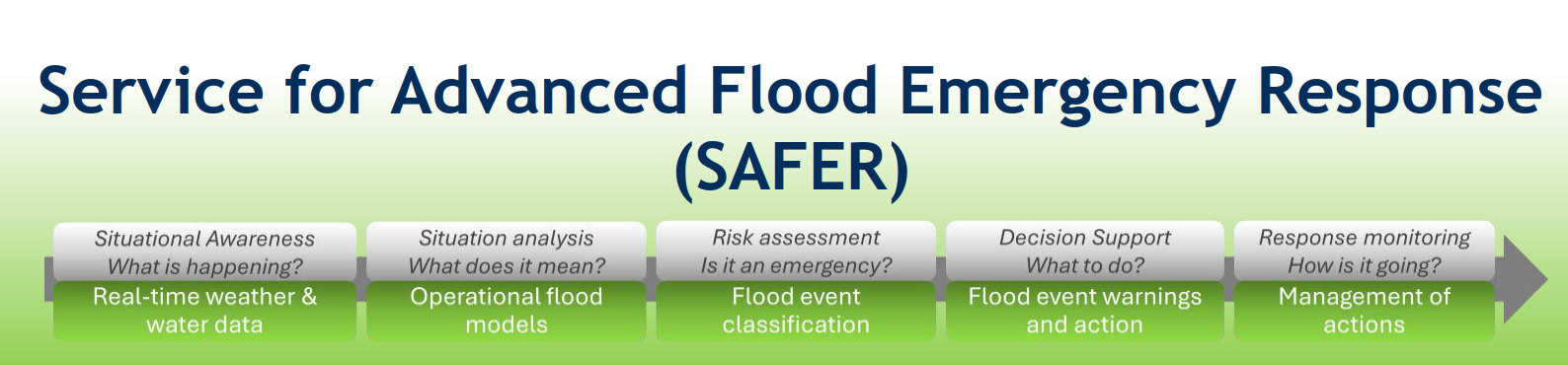
SAFER: From Improved Situational Awareness to Flood Forecasting and Emergency Response
SAFER (Service for Advanced Flood Emergency Response) is an action-research initiative developing a practical framework for improved flood forecasting, situational awareness and emergency response.
This webinar will showcase progress to date, including
- The five stages and 4 tiers of SAFER
- new weather and water control room dashboards providing enhanced access to weather and water data,
- improved access to and visualisation of MetService radar rainfall (QPE) products, RainCast and WRF forecasts,
- The new WISER Storm Risk rainfall exceedance tools for both observed and forecast conditions.
- An update on the project's tiered flood forecasting approach, including machine-learning forecasting trials in the Thames–Kauaeranga catchment and hybrid forecasting solutions being developed for the Waipā, Waikato and Hauraki river systems.
Looking ahead, SAFER aims to connect forecasts, alerts, operational procedures and task management within a single operational environment, helping agencies access better information before, during and after flood events to support more informed and coordinated decision-making.
Presenters: Brian Jackson, Water Technology and Rick Liefting Waikato Regional Council
Process-based stream restoration using low-tech woody debris structures (Geomorphic Brushwood Structures, or GBS; known internationally as BDAs/PALS) have shown great success abroad. In North America and Europe, these structures are stabilising eroding streams, rebuilding aquatic habitat, and reducing sediment loads, all at a fraction of the cost of conventional form-based engineering. But those successes are in different geomorphic contexts, with different native species and riparian vegetation. New Zealand has never deliberately designed and installed these structures as a restoration strategy. Yet they occur naturally in our streams...Whatipu's own network includes natural examples, demonstrating that the geomorphic and ecological conditions here already support this form of wood structure and its benefits. This webinar introduces the concept and the evidence behind these structures, then dives into Whatipu: Auckland's first rigorous trial to test whether strategically placed versions can amplify what nature already does in our ecological and geomorphic setting. We'll walk through the proposed design, the monitoring framework, and what we hope to learn before rolling this out across the region.
Does low-tech restoration belong in Auckland's toolkit? Come with an open mind and a willingness to think differently about how streams stabilise themselves.
Presenter, Danny Klimetz, Auckland Council
In February 2023 the east coast of Te Ika-a-Māui/ the North Island of Aotearoa New Zealand was severely impacted by ex-Tropical Cyclone Gabrielle (ETC Gabrielle), leaving a trail of destruction and 9 fatalities. The east coast has a relatively high level of exposure to the impacts of decaying ex-tropical cyclones that move south out of Melanesia/ western Polynesia, often tracking across Hawke’s Bay. ETC Gabrielle was particularly intense with sea surface temperatures in the Tasman Sea playing a part in maintaining that intensity. It’s speed and track brought unprecedented wind, rain and waves/ storm surge - some rain gauges recorded in excess of 500mm in 24 hours and peak intensities in excess of 50mm/hour. Accordingly the damage associated with this event was catastrophic for parts of Hawke’s Bay, in some places shifting residential buildings off their foundations and in other places completely burying houses in silt.
In the weeks following that event central Government instructed local councils to categorise the risk of continued occupation of impacted residential properties, with the highest risk subject to a voluntary Crown ‘buy-out’. PDP was engaged by HBRC to assist with that categorization and in particular that highest risk Category 3 delineation, based on the broad ‘risk to life’ consideration that were so dramatically highlighted with the event – the depth of flooding, velocity, rate of rise, entrained silt and debris volumes. It also included a range of other considerations – geographic features that concentrate the hazard, the availability of safe egress and the complexity of the hazard. The work culminated with the identification of close to 300 Category 3 residential properties subject to voluntary buy-out and the confirmation of around $200M in funding (excluding insurance payouts). The presentation will provide a summary of that work and highlight some of the challenges associated with it.
Ramon is a river engineer with over thirty years’ experience in the field of civil engineering and has just short of 20 years’ experience in regional sector leadership roles mainly with Otago and Manawatu-Whanganui (Horizons). He’s a Chartered Professional Engineer and current part of the NZ Society on Large Dams management committee.
Digital Badges
Āpōpō - Asset Management and Flood Risk Management Training
Discounted online digital badge training and public training courses
- a 10% discount of Āpōpō ’s award-winning digital badge programme and public training. From the essentials of asset management through to more advanced badges that cover different subjects in more detail and are appropriate for more experienced practitioners. Choose which digital badges suit you or your team and do them at your own pace online, anytime and anywhere.
- Āpōpō’s three specialist WM badges on Flood Risk Management.
Discount code to enter during checkout: resilientrivers10
Click here to choose your training, then use the discount code at checkout: Digital badges - Build your knowledge - Āpōpō (apopo.co.nz)
Contact training@apopo.co.nz with any specific questions on their training.
Previous workshops
As these are paid workshops we do not share the content for them online.
2025
- Willows & Populars Bio Engineering
- Nature based solutions
- Rock design
2024
- River management practice
- Strategic overview of rivers and catchments geomorphology, and river management
- Over-design event
- Room for the river
- Rock design
- Flood warning symposium
- Gravel management
- Essentials of engagement
- Asset management
2023
- Hydrology
- Strategic overview of rivers and catchments geomorphology, and river management
- Tools and fluvial geomorphology
- Communication and engagement
- Project Management Prince 2 foundation
- Taiao masterclass
- River management practice
- Room for the River
Previous field trips
2025
- Gisborne Rivers Recover field trip
2024
- Hawke's Bay field trip
- Canterbury flood recovery field trip – CANCELLED
- Field Trip to Rangitata Diversion Race
2023
- Operational practice - Bay of Plenty Regional Council field trip